You are here: Home / Case studies / EU3 - Forest fires
case: EU3 location: Europe sectors: Forestry

Question

Which question has been addressed in this step?

Exploring risk: What is the impact of climate change on forest fire risk (probability x burned area) in Europe?

Case step navigator: click any node to select the respective step

Why has this question been chosen?

  • Because changes in fire regimes may have strong impacts on natural resources and European carbon cycle. 
  • Changes in fire regimes may have strong impacts on natural resources and ecosystem stability, with consequent direct and indirect economic losses. 
  • There is little work on the development of climate change adaptation policy in the forestry sector. This is partly because the impacts of climate change on forest fires is still unclear.
    Addressing this question should provide more understanding.

Which methods have been applied?

  • Calibration and validation of the Community Land Model 4.0 fire routine (CLM Fires) against an independent database of forest fires will be performed (European Forest Fires Information System - EFFIS - and Global Fires Emissions Database – GFEDv3).
  • Empirical emission factors will be applied to CO2 emissions from forest fires modeled with CLM-Fires
  • Exploiting the statistics of fires suppression time at NUTS3 level we calibrated the parameters governing the fire ignition and suppression for the application at pan European scale and we consistently quantified the uncertainty and distribution of parameters governing ignition and suppression.
  • The model was tested for the period 1990 to 2009 comparing the results with area burned reported in satellite based global fire products and with burned area statistics at country scale provided by the European Forest Fires Information System.

Why have these methods been selected?

  • The CLM model represents the state of art of land surface model including forest fires.
  • A few models have been suggested in literature to characterize global and regional fire occurrence with different structures and drivers.
    These models have been usually validated only for a handful of locations, and substantial work is required to use them effectively on a global and continental scale.
  • Often, in modelling studies, ignition/suppression is considered function of population density and the parameters governing the ignition and suppression functions are kept constant in time and space. However, ignition and active suppression is the consequence of cultural, socio-economic factors and also of firefightning policies,resources and degree of fire management.

What results have been obtained?

  • The time series of modelled burned area is shows good agreement with observed burned area. Results are reported in Fig. 1 of Khabarov et al. (2013).
  • The calibration and refining of the CLM model lead to an improvement of its performance in describing burned area and emissions from fires. Therefore, with the developed operational modeling framework we can extrapolate forest fires risk, burned area and emissions under climate change scenarios with a certain confidence.


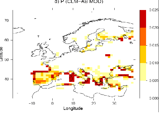
Figure 1 - Fire probability in Europe computed with the refined CLM Fires model (Figure modified from Migliavacca et al., (2013), Modeling burned area in Europe with the Community Land Model. Journal of Geophysical Research Biogeoscience)


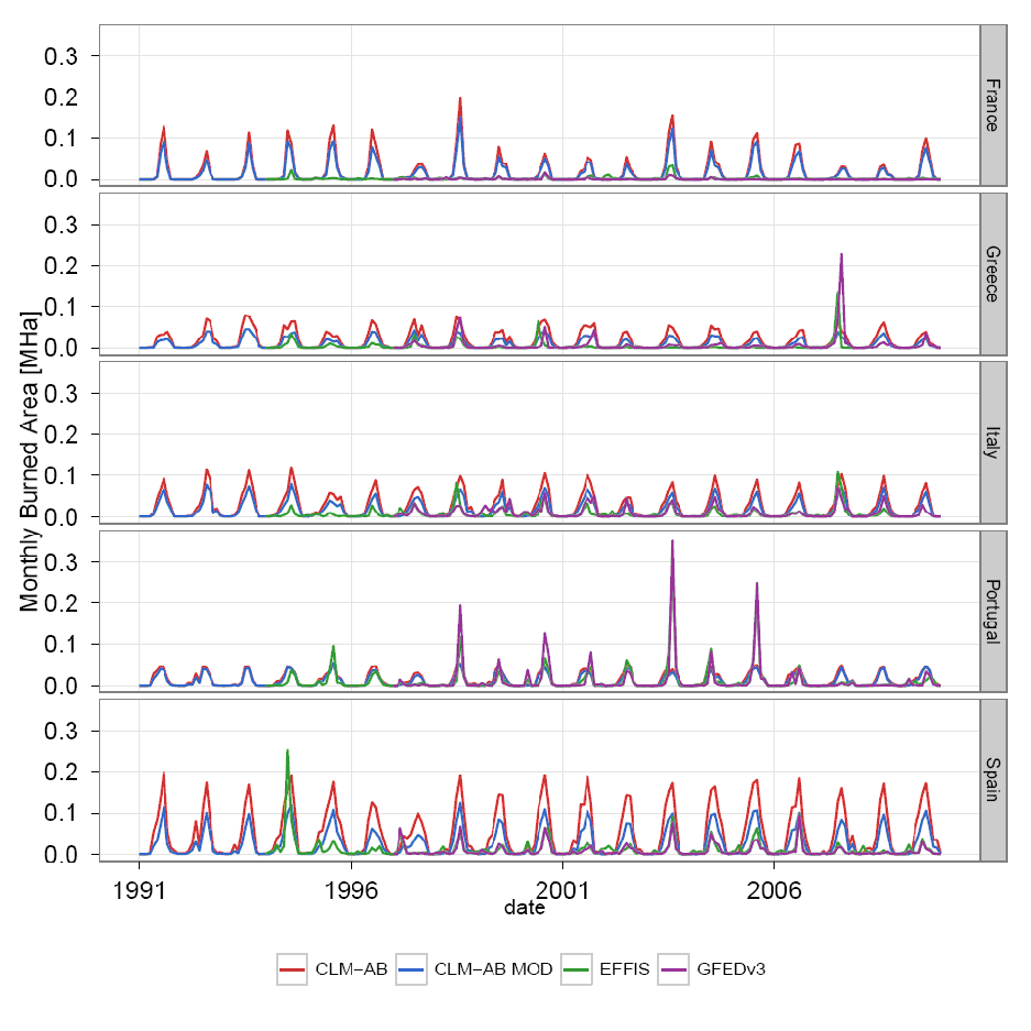
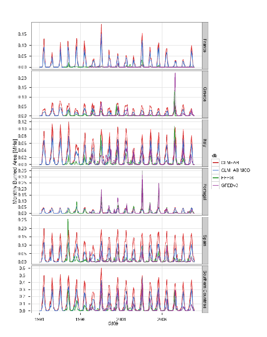
Figure 2 Monthly burned area for the 5 European countries that mostly contribute to the continental burned area (France, Italy, Spain, Portugal and Greece) and its sum (Southern countries). Red and blue lines represent the burned area simulated with CLM-AB (original model parameterization) and CLM-AB MOD (calibrated model), respectively. Green lines represent the monthly burned area reported in the European Forest Fires Information System while purple lines the burned area reported in the Global Fires Emission Database GFEDv3 (Migliavacca et al., 2013).


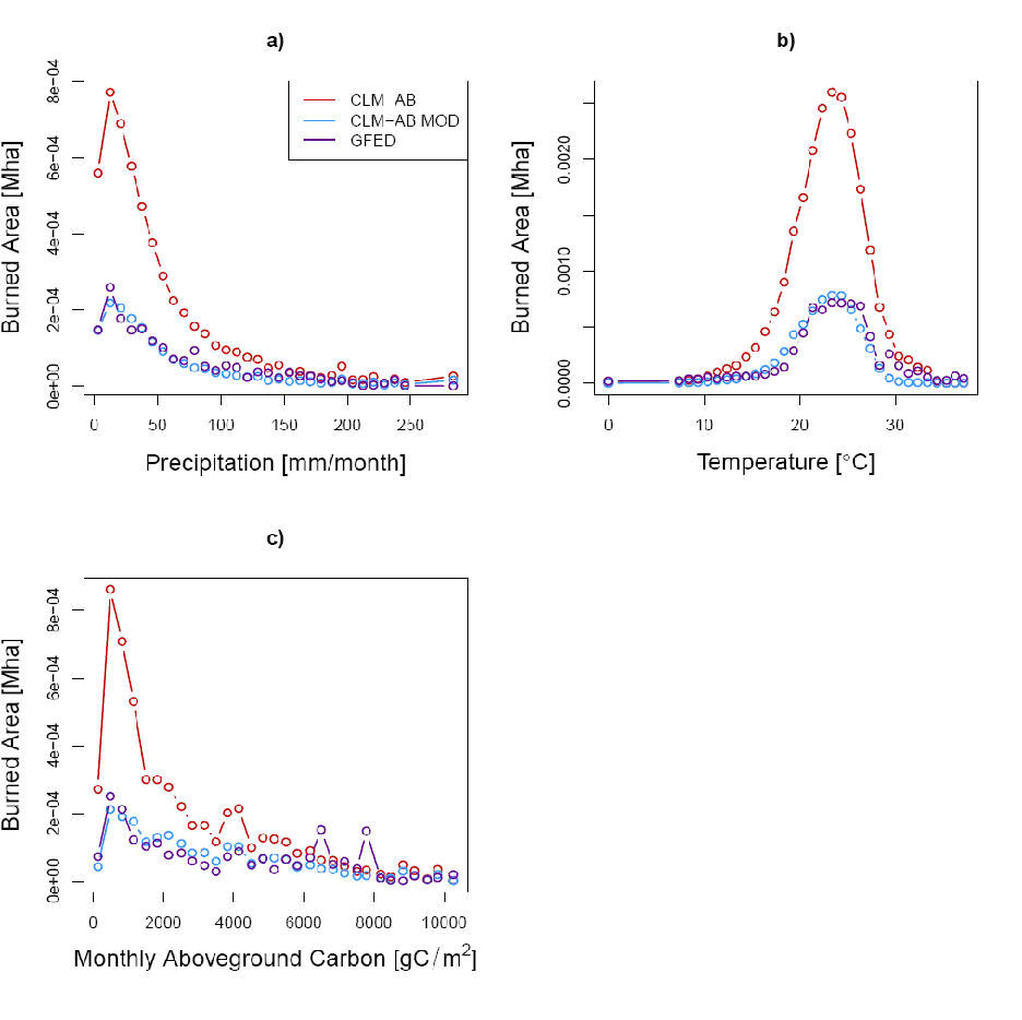
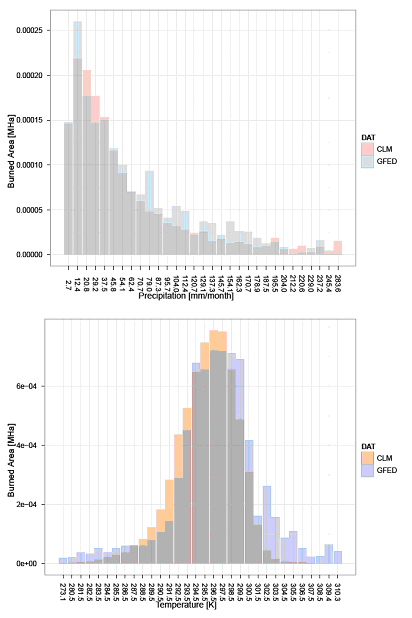
Figure 3 - Burned area in bins of mean monthly temperature (a), precipitation (b) and aboveground biomass (c) according to CLM--AB (Red lines), CLM--AB MOD (Blue lines) and GFED (Purple lines). This graphics show that the observed relationship between burned area and climate (purple line) is well described by the calibrated model (CLM-AB MOD).

Reflections on this step

  • Fire module will be calibrated using historical data, hence our extrapolation of forest fires under CC will hold only for reasonable deviations from the current climate.
  • In particular, model fail in the description of the influence of human activities on fire suppression and ignition and often the parameterization employed are the outcome of few local scale works and therefore not calibrated for pan European studies.
  • Although this information is not available globally, regional and continental efforts toward the collections of data and statistics on fires can provide important information to improve understanding of the human influence on fires and to improve the parameterization of ignition/suppression functions in fires models

Pathfinder

MEDIATION Toolbox

Toolbox detail page(s) available for methods and tools applied in this case step:

Community Land Model

Details on this case study step


The impact of climate change on fire risk have been quantified using a fire model included in a state of the art land surface model (Community Land Model, CLM).

A few models have been suggested in literature to characterize global and regional fire occurrence with different structures and drivers

These models have been usually validated only for a handful of locations, however, and substantial work will certainly be required to use them effectively on a global and continental scale.

In particular, model fail in the description of the influence of human activities on fire suppression and ignition and often the parameterization employed are the outcome of few local scale works and therefore not calibrated for pan European studies.

Often, in modeling studies, ignition/suppression is considered function of population density and the parameters governing the ignition and suppression functions are kept costant in time and space.

However, ignition and active suppression is the consequence of cultural, socio-economic factors and also of firefightning policies, resources and degree of fire management.

Although this information is not available globally, regional and continental efforts toward the collections of data and statistics on fires can provide important information to improve understanding of the human influence on fires and to improve the parameterization of ignition/suppression functions in fires models.

Exploiting the statistics of fires suppression time at NUTS3 level we calibrated the parameters governing the fire ignition and suppression for the application at pan Eurpean scale and we consistently quantified the uncertainty and distribution of parameters governing ignition and suppression.

The model was tested for the period 1990 to 2009 comparing the results with area burned reported in satellite based global fire products and with burned area statistics at country scale provided by the European Forest Fires Information System.The time series of modeled burned area is reported in Fig. d-1

Finally we evaluated the capability of the model to mimic the relationships between temperature, precipitation and burned area observed (GFED) and modelled (CLM calibrated) in Europe.The distributions of burned area in bins of temperature and precipitation are reported in Fig d-2 and show a good agreement between the observed and modeled relationship between burned area and climate (temperature and precipitation).

The calibration and refining of the model lead to an improvement of its performance in describing burned area and emissions from fires. Therefore, with the developed operational modeling framework we can extrapolate forest fires risk, burned area and emissions under climate change scenarios with a certain confidence.We then conducted runs to 2100 using as forcing climate scenarios of the ENSEMBLES FP7 Project (Scenario A1B).

Figure d-1 Monthly burned area for the 5 European countries that moslty contribute to the continental burned area (France, Italy, Spain, Portugal and Greece) and its sum (Southern countries). Red and blue lines represent the burned area simulated with CLM-AB (original model parameterization) and CLM-AB MOD (calibrated model), respectively. Green lines represent the monthly burned area reported in the European Forest Fires Information System while purple lines the burned area reported in the Global Fires Emission Database GFEDv3 (Migliavacca et al., in prep).

Figure d-2 - Distribution of burned area in Europe in bins of temperature and precipitation (Migliavacca et al., in prep)