SLR potential inundation area for 1m, 2m, 3m above sea-level and derived information
|
These maps indicate areas at risk through sea level rise. To begin with, area (in km2) below 1, 2 and 3 meter elevation that is hydraulically connected to the sea according to the 8 rule is given for a worldwide 0.5° grid. Additional the percentage of specific land class types, such as agricultural, pasture and urban land at risk is given for each cell in this 0.5° grid to highlight priority areas of vulnerability against floods and sea level rise.
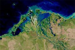
Figure 1: SRTM90 example of the coastal area around Vietnam's biggest city. The base map is the MODIS land-use data, where red indicates urban areas. The dark blue areas are the SRTM90 derived areas under 3m with a connection to the sea. For a sea-level rise or a flood event of 3m approximately 9% of the worldwide coastal urban areas are at risk. However, there are large regional differences. Interpretation aid and possible limitations The 0.5° grid gives a global overview of areas threatened by floods and sea level rise and distinguishes between different types of land-use. However, it can not replace local case studies since it provides no information about coastal erosion, salt water intrusion or other to sea level rise related issues. The main consideration to make here is that SRTM data is not available beyond 60 degrees northern latitude. Due to this fact it is not possible to identify vulnerable areas above this extent. Method First, a regular grid of 0.5x0.5° was created. The grid had to be restricted to the coastal region. How far inland the grid should go was determined by the area extent of land area below 3 meter elevation and hydraulically connected to the sea. Land-area below 1, 2 and 3 meter elevation and hydraulically connected to the sea was determined following the 8 neighbour rule algorithm in the R SRTM - Tools package [1]. The rule was applied to the SRTM90 database of terrain elevation with a 90x90 meters spatial resolution and a vertical resolution of 1 meter. The "potential flood extent" was then overlayed with the regular grid and cells extracted. For each grid cell the "potential flood extent" was calculated in km2. 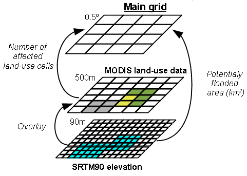
Figure 2: Data generation of the 0.5° main grid based on the digital elevation model SRTM90 with a resolution of 90m and the MODIS land-use data with a resolution of 500m. A similar procedure was employed to determine land-use grid classes threatened by potential inundation. The "potential flood extent" described above was overlayed with land-use data from MODIS data (circa year 2010) product with a spatial resolution of 500x500 meters. MODIS grid cells coded as agricultural (12 & 14), pasture (10) and urban-land (13) that touch the "potential flood extent" are extracted, summed up and accounted to the corresponding grid. The main consideration to be made here is that all land-use cells are extracted independent of the extent to which they are affected by the "potential flood extent". This may arguably lead to some over-estimations of land-use threatened by a potential flood. It is also important to say that the information of land-use in each MODIS cell is an average of dominant land use. References [1] SRTM - Tools, Steffen Kriewald, 2012, R package version 2012-0.2 Data sources For the elevation information CGIAR-CSI (2006): NASA Shuttle Radar Topographic Mission (SRTM) was used. The SRTM data is available as 3 arc second (approx. 90m resolution) DEMs. The dataset is available for download at: http://srtm.csi.cgiar.org/; December 20th 2011. The MODIS dMCD12Q1 product version 5.1 2010 was used for the land-cover information. Downloaded from the data pool ftp://e4ftl01.cr.usgs.gov/MOTA/MCD12Q1.051/; August 22nd 2012. |