|
ci:grasp performs as a climate information service and provides sound knowledge on current and projected climate stimuli, climate impacts and adaptation options at the national, sub-national and regional level.
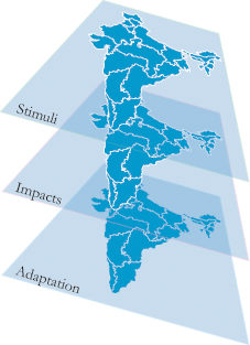
The layer system
The information in ci:grasp is organized via a layer structure.
Layer 1: Stimuli
Provides you with information regarding selected climate stimuli, sea-level rise, precipitation and temperature. The information level is global with a resolution as fine as possible. The data used to depict the information via maps has been derived by analysing historical time series and - for future projections - has been extracted from climate models. Each map holds meta-information regarding methodology, data sources and the contents of the map.
Layer 2: Impacts
Gives you an idea about key impacts with respect to different stimuli in your region. For example as you choose sea-level rise an impact may be the potential loss of agricultural production Such information is displayed with the help of maps. Each map holds meta-information regarding methodology, data sources and the contents of the map.
Layer 3: Adaptation
Supplies you with information on adaptation projects that are targeted at specific impacts. The information is structured with respect to a pre-defined adaptation classification system and each adaptation project is mapped onto the map for ease of reference. Combining adaptation information with a corresponding impact or stimulus map supplies valuable information about whether existing adaptation projects potentially take place at a relevant location. The adaptation classification system works on the base of impact chains. Each adaptation project can be viewed in detail and the location of the project in the corresponding impact chain will be indicated.
Literature
A list of relevant literature used for ci:grasp can be found in our bibliography.
|