F. Toussaint (PIK, Potsdam), M. Lautenschlager (DKRZ, Hamburg), M. Reinke (AWI, Bremerhaven)
The CERA Database Structure
BfG Conference Koblenz 22.-26.3.99: "...Data for Hydrology..."
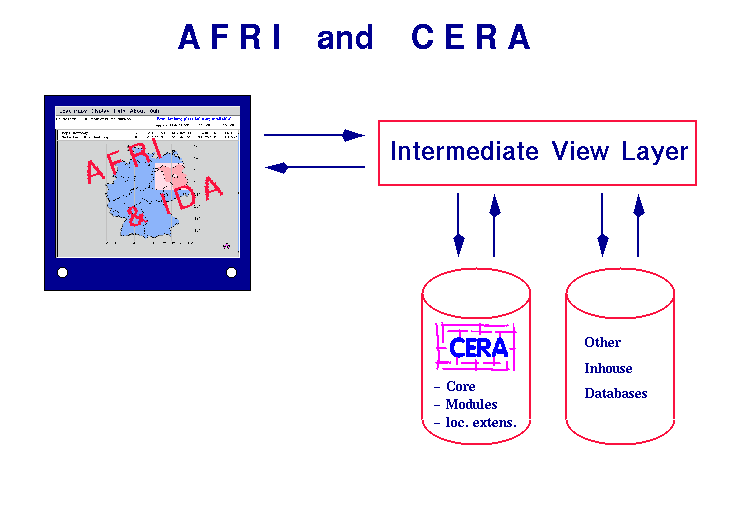
 What are CERA and AFRI ?
- Climate and Environmental Data Retrieval and Archiving System: a database (DB) structure of tables to store spatial data and metadata
- A Flexible Retrieval Interface: a web/Java-based graphical user interface (GUI) to generate DB queries
- Interactive Digital Atlas: an IO facility, allowing for region selection, station display, and more... - integrated into AFRI
- diagram
Why Federated (Meta) Data ?
- to match the requirements for geographically distributed data storage in different institutions
- less expenses for tools, user interfaces, installation
- problem: very inhomogenious data of different structures
Requirements
- common, transparent access to (meta) data of all project partners
- high flexibility for all kinds of spatial data (model, station and other)
- open structure; as far as possible: simple structure
- compatibility to content standards (NASA-DIF, FGDC-CSDGM etc.) and functional standards (IEEE etc.)
Project CERA-2
- collaboration:
- Potsdam-Institut für Klimafolgenforschung (PIK, Potsdam)
- Deutsches Klimarechenzentrum (DKRZ, Hamburg)
- Alfred-Wegener-Institut für Polar- und Meeresforschung (AWI, Bremerhaven)
- Forschungszentrum Karlsruhe (initially; FZK, Karlsruhe)
- very different data structures
- workshop in WWW: description and discussion of developers
- draft - implementation - further planning (modules)
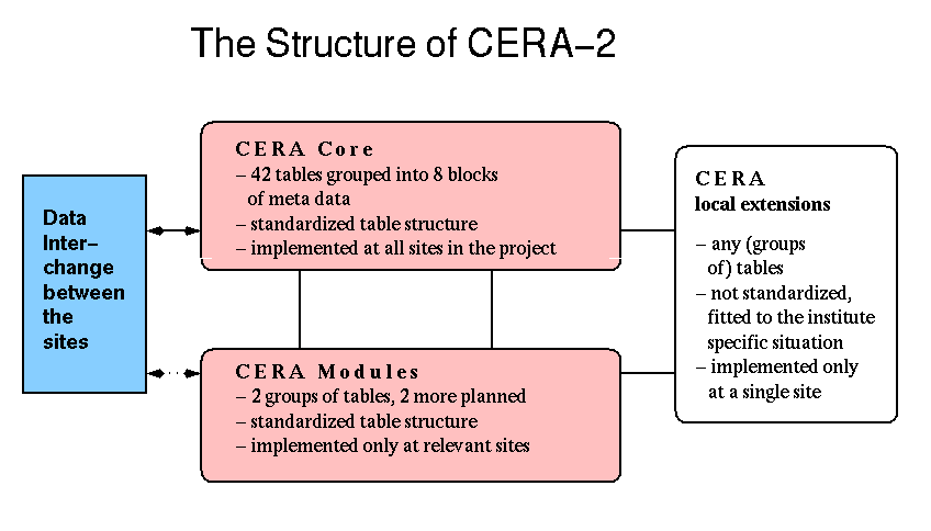
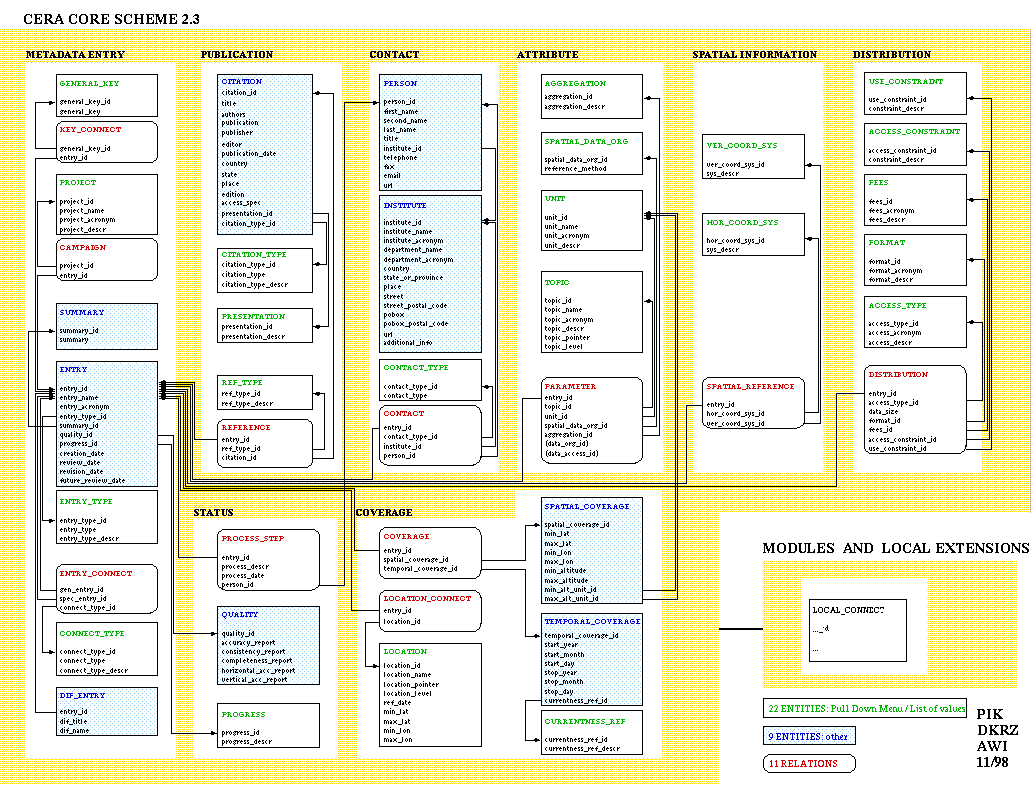
- split of CERA into a core part (CERA Core = 58 tables) and modules for certain installations and local extensions - diagram
The CERA Core
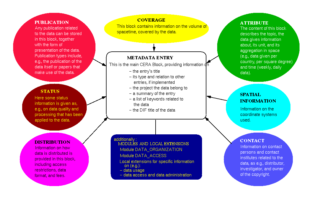
- divided into 8 information blocks (= groups of tables)
- the CERA-2 Blocks: for coverage, quality, status, access (e.g.) - diagram
- the CERA-2 tables: 11 relations, 9 LOVs - diagram
- 22 lists of values (LOVs) to facilitate the input by pull down menues
The CERA Modules
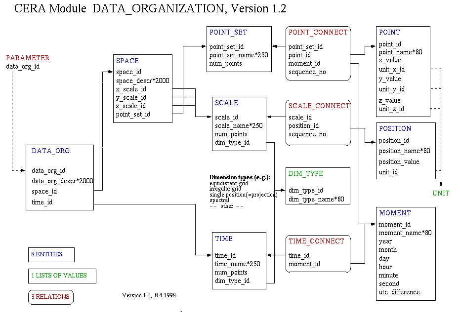
- module DATA_ORGANIZATION - diagram
describing the structure, by that the data reference the four dimensional spacetime (e.g. description of axises)
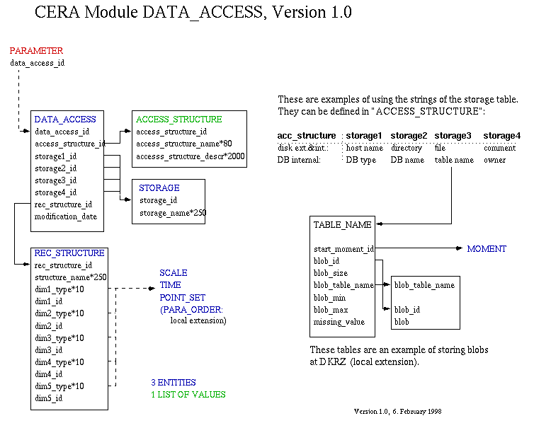
- module DATA_ACCESS - diagram
informations for automated access
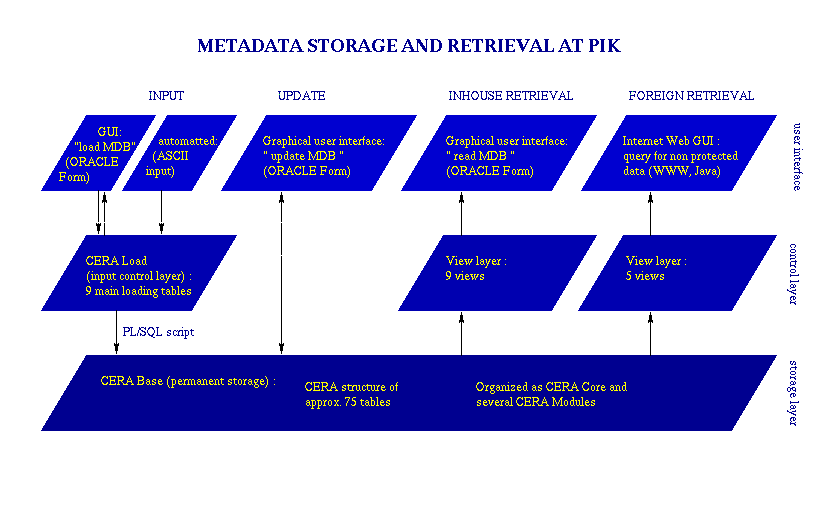
Installation
- DDL-SQL and SQL-tools in WWW
- loading layer
- ORACLE Forms surfaces for: read, load, update
- CERA-2 running at PIK - diagram
- open development (modules)
- tools for normalized data export (NASA-DIF, FGDC-CSDGM) in preparation
Use of CERA-2 for Hydrological Meta Data
- especially adapted to handle spatial meta data ...
- ... about physical measurements (waterlevel, discharge)
- ... of very different storage formats
- quality information is kept (FGDC): accuracy, consistency, completeness, horiz. & vertical accuracy
- extensible: individually for single sites (local extensions) and for groups of institutions (modules)
- existing data (files, DBMS) can be integrated
Further Information
- CERA-2 Central Page: http://www.pik-potsdam.de/dept/dc/e/sdm/cera/
- DKRZ Technical Report No. 15 (Lautenschlager, Toussaint, Reinke; paper and web-version)
- CERA-2 - ein raumbezogenes Daten- und Metadatenmodell (Toussaint, Lautenschlager, Reinke); in Ralf Kramer & Friedel Hosenfeld (eds.): Heterogene, aktive Umweltdatenbanken; GI-Workshop Vilm 1998, Metropolis-Verlag, Marburg 1999
0
1
2
3
4
5
6
7
8
9
- NEXT