Ecosystem services and land-use under global change in the Haute Provence
Report of the Excursion day
1 Plateau de Valensole
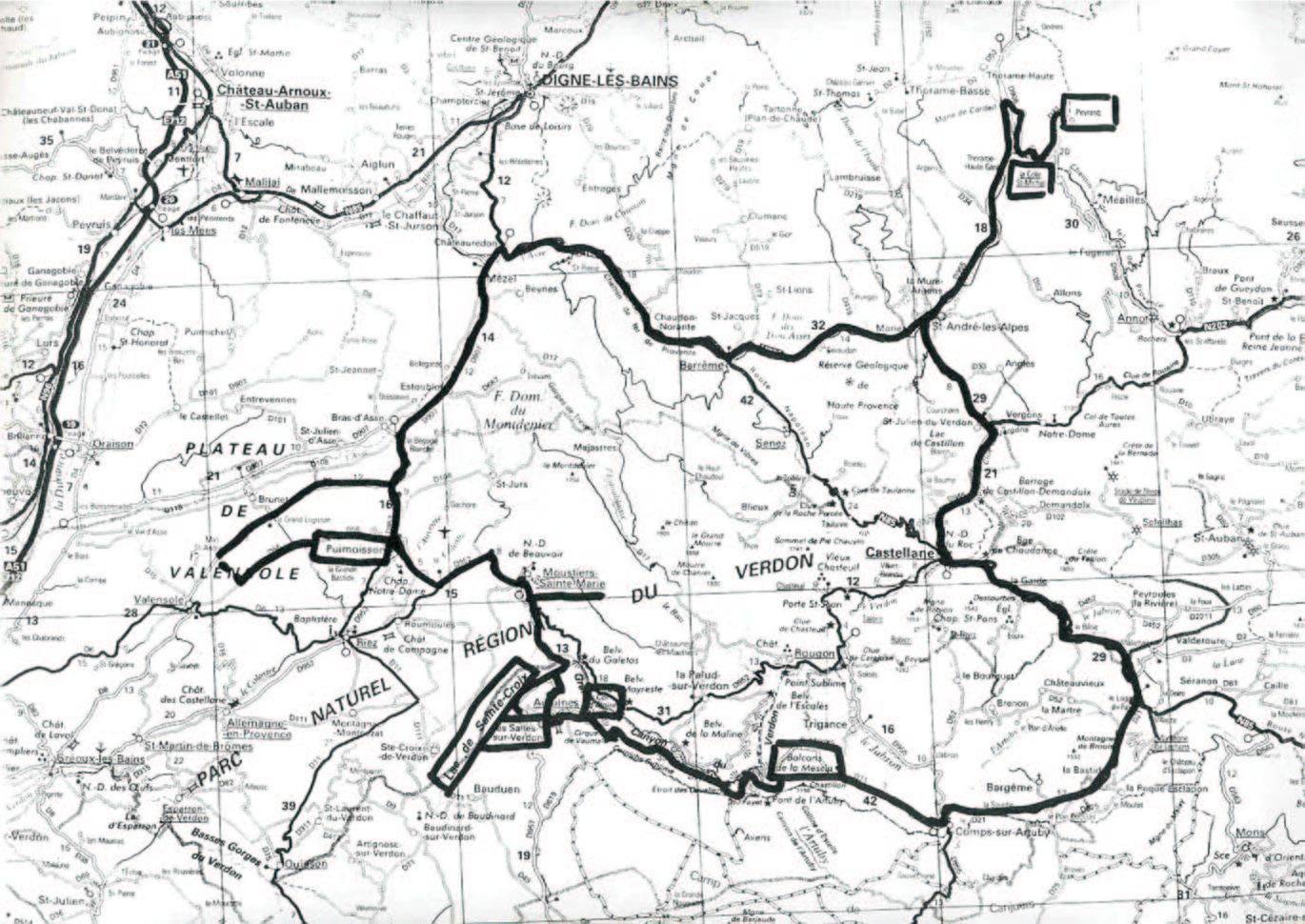
The Plateau de Valensole is located in South-Eastern France, and surrounded by the Western Alps and in the NW part by the Parc Naturel Regional du Verdon. The average altitude of the plateau is 600m. It has a specific topography, structured by deep valleys of the rivers l’Asse and le Verdon.
The area is an important area of specific crops, so-called ‘cash crops’ since the Middle Ages. The most dominant crops are lavender, truffles, wheat, almond trees and oaks. Those crops create a specific colour palette for the Provence region, recognized as a specific feature of the region. Particularly, most famous is the blue/violet from the lavender, the yellow of wheat fields and the white from almond flowers.
The agricultural pattern of the region has changed and will change quite rapidly in accordance to prices for crops and products. From the beginning of agriculture, the plateau was mostly used for wheat production, sold to people from coastal areas. The common agricultural method was intercropping, almond trees with wheat, later grapes and oaks. At that time since the 19th century, the area was quite closed, as fields were covered with many almond trees. In the 19th and beginning of 20th century the demand increased for high quality lavender flavours and the intensive production of fine lavender started. The landscape became open and got the look we can enjoy nowadays.
During the last decades, the fine lavender is the dominant crop in the region. Its growth cycle is about 5-10 years. It is a specific type of lavender, grown for pharmaceutical-perfume companies for flavours. However, even nowadays single almond trees can be seen in lavender fields. Fine lavender requires conditions of latitudes between 500-1000m. Nowadays, as prices on lavender have large fluctuations, it has decreased in area in prevalence of new oak plantations for truffles. However, the time-lag for first crops of truffle is 10-15 yr. Irrigation of the land for maize and almonds has never been profitable, but even now, new owners try it from time-to-time. In the last decade the olive prices increased and now olives are not only grown next to the farms by 5-10 trees, but larger orchards started to be cultivated. This means that the landscape is changing to a bit more structured one, which does not make the tourists happy. But as the price for lavender has been stabilized a bit more and there is stable demand for lavender new fields are planted.
Land-use change caused also change in settlements density. Until the middle of the 19th century, the population density of the region was very high. Then it decreased tremendously during the next 100 years. Nowadays, people start to return but mainly using this region for second homes for vacations or weekends and prices for houses increased about 10-20 times.
Jaan Liira
2 Les Salles sur Verdon and Lac de Ste Croix
Part I: History of Les Salles sur Verdon
The history of the village of Les Salles sur Verdon dates back to the beginning of the 12th century. In the 19th century, the village was home for over 300 people—many of them farmers or shopkeepers with lasting connection to the land and a strong sense of place. The village and farmlands were located at the entrance to the gorge of the River Verdon, picturesquely carved into the limestone. An open agricultural landscape has been symbolic to the region. The region is characterized by Mediterranean climate favourable to olive groves, lavender, truffles, oak trees, and livestock. Millions of years ago, the site of the old village was at the bottom of a sea. Gradually the rainwater infiltrated the limestone and now brings water to the Les Salles sur Verdon water reservoir—the only water reservoir in the Provence region of France. Water, therefore, has long been perceived as a precious resource and water sources have been valued as a place for social gathering.
Part II: Demolition and Reconstruction of Les Salles sur Verdon
In the early 1970s, a short supply of water to the coastal region of France was recognized and the solution was to build a dam on the River Verdon. In the 1971–1974 period, the demolition of the Les Salles sur Verdon village began parallel with the construction of the new village and the building of the dam wall. During demolition the lake water level was rising but many people reliant on their farmlands still lived in the village and witnessed the demolition of their social landscape. Those opposing the project did not hesitate to express their disapproval in graffiti and in the local media publications. The church was the last building to be demolished and the only building demolished with dynamite. The entire village was demolished to prevent the wood in the house foundations interfering with the water turbines of the new hydroelectric power plant, and to prevent damage to the buildings from water movement. The mayor’s house and a new school and church were the first three buildings in the new village. The school had one student the first year, four students during the second year, and eighteen students at present. Between 60 and 80 people have made homes in the new village—a substantial decrease from over 300 inhabitants before the demolition. Many people migrated to neighbouring villages, as the compensation they received was insufficient for them to settle in the new village. Since then, the local government has been giving incentive to new residents, however without much success. The inauguration of the new village was conducted on January 19, 1977, however, the organizers forgot where they set the first stone and only exacerbated the loss of thrust in the residents. The residents are unhappy with the larger streets and plazas, barely reminding them of the main venues for their social life.
Part III: Tourism in Lac de Ste Croix
From 1975 to present, the village has witnessed a shift from agriculture to tourism; tourists were attracted to the lake waters but many farmers entirely dependent on their agricultural production were forced away. Tourism, however, is only seasonal and the number of tourists at the lake is relatively small to sustain the annual income of the local population. Records show that the lake, dam, and village are visited by some 20,000 tourists in the summer only and concentrated in three or four places. The bottom of the valley is rich and favors the growing of oak trees (produced for truffles) allowing local farmers to supply over five tons of truffles (valued at 1000 Euros per ton in 2005), which indisputably helps to the economic growth of the region.
Summary of Facts
3 Parc naturel régional du Verdon
The Canyon of Verdon is the second largest in the world after the Grand Canyon. Situated in the Alps of the 'Haute-Provence', the park covering an area of nearly 18'000 square kilometres was founded in 1997 and is managed regionally. A project funded by the French government tries to model the near future (30 years) of the land use of the park. The aim is to preserve open landscape, which is an important part of the local population's life style. The model is an 'agent based model' meaning that stakeholders are the primary drivers of the model. Initially, a biophysical model partly based on aerial images taken 50 years ago and every 10 years thereafter was built. Then the stakeholders are involved. Farmers, hunters, foresters, natural scientists and providers of tourist accommodation were identified as the most important stakeholders in the area. Interestingly, mayors were not among them.
Projections for the future showed a large increase in forest area in the park, which was interpreted mainly by land abandonment in consequence of a decrease in farmer's incomes.
After the presentation, we visited the southern side of the canyon where we were shown some areas of forestry growth due to reduced sheep grazing. The view of the canyon was highly impressive and will continue to provide tourist attractions in the future.
Sebastian Leuzinger, Signe Poulsen| |
AVEC
is a EU FP5 Concerted Action No. EVK2-CT-2001-20010
|
back to the
AVEC
Summer School Programme
back to AVEC |