Example: The Climate Projection Explorer
Screenshot detail |
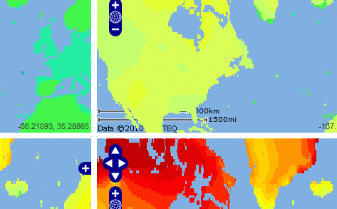
The interactive Climate Projection Explorer has been developed to allow exploring maps of 4 different climate projections simultaneously, e.g. to compare projections from different global circulation models, for different scenarios or different time periods.
The Climate Projection Explorer consists of four coupled interactive maps to greatly facilitate co-ordinated zooming and panning to regions of interest.
Available as part of the stimulus module of the Climate Impacts: Global and Regional Adaptation Support Platform (ci:grasp).
Examples
Information systems
Tailored interactive components
|
|