ci:grasp map comparator - climate projections (SRES AR4 scenarios)
|
mm
| ||
xxx
| xxx
| |
xxx
| xxx
| |
Note:
Please avoid over-interpreting the maps. Maps only have a certain explanatory power. For example, the data presented on the interactive world map is not applicable for highly localized projections, forecasts, and "ground truthing" events and processes there.Please make use of the ci:grasp glossary to clarify terms you are unfamiliar with.
It is helpful to discover whether and where adaption measures are currently taking place, and what type of impacts they address. You can search for adaptation projects in our adaptation project database.
Please refer to the ci:grasp list of references for an ample body of scientific literature. The references in the text throughout the platform are collected there.
General information
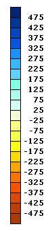
These maps depict the difference in average temperature or precipitation between a baseline period (1961-1990) and a selectable timeframe (2001-2030, 2011-2040, 2031-2060, 2041-2070 or 2071-2098), based on projected under the SRES scenarios A1B, B1 or A2 by the global circulation model MPI ECHAM5, UKMO HadCM3, GFDL CM2.1, MIUB ECHO-G or NCAR CCSM3.0.Maps are available for annual and for seasonal temporal aggregations. They depict whether the output compared to the baseline scenario is projected to increase (positive value), decrease (negative value), or to remain unchanged (value of zero).
The color blue indicates a decrease in temperature, while red indicates an increase in temperature.
Methodology
Historical and projected temperature values have been obtained from the MPI ECHAM5, UKMO HadCM3, GFDL CM2.1, MIUB ECHO-G and NCAR CCSM3.0 global circulation models for SRES scenarios A1B, B1 and A2. The data has been used to calculate 30-year averages of temperature both for the baseline period and the periods 2001-2030, 2011-2040, 2031-2060, 2041-2070 an 2071-2098. These results have then been used to produce the difference map sshown here. Data has been bilinearly interpolated to a global grid of 0.5°x0.5° and been bias corrected to CRU-PIK (Österle, H., Gerstengarbe, F.-W., Werner, P.C., 2003).Data Sources
| Dimension | Dataset name | Unit | Scenarios | Resolution | Source |
| temperature, precipitation | IPCC GCM output (MPI ECHAM5, UKMO HadCM3, GFDL CM2.1, MIUB ECHO-G, NCAR CCSM3) | °C; mm | A1B, B1 and A2 | GCM resolution | IPCC (http://www.ipcc.ch/); WCRP CMIP3 Multi-Model Database (http://www-pcmdi.llnl.gov/) |