you are here: home / city module / cathy: climate assessment tool for hyderabad
City module - CATHY: Climate Assessment Tool for Hyderabad
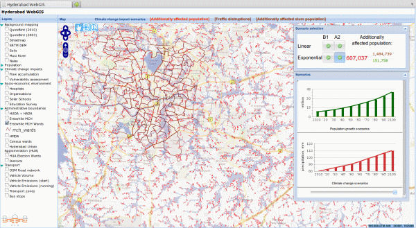
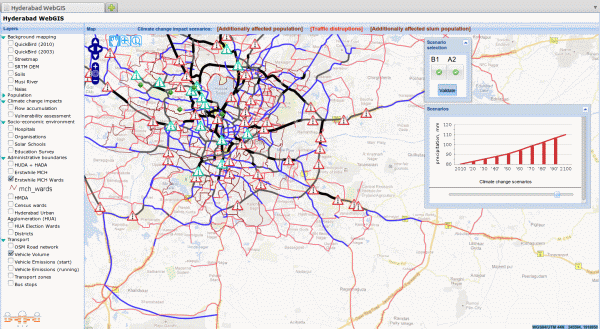
The Climate Assessment Tool for Hyderabad (CATHY) is a WebGIS software tool which allows for an interactive temporal and spatial analysis of explicit climate change impacts for different combinations of scenarios. CATHY constitutes a prototype urban decision-support system specifically tailored for climate-related issues of the city of Hyderabad, India, and aims to become an important mechanism for Hyderabad's decision makers in assessing the possible impacts of climate change under various climate and socio-economic development scenarios. The open source architecture and functionality of the decision support tool provides a richly knowledgeable and cost effective means for continuous assessment of policy and technological decisions in view of often diverging climate change scenarios. The tool extensively uses high resolution satellite imagery analysis techniques and incorporates a custom developed slum detection algorithm and a flood risk model. It is also able to perform an assessment of vulnerability to extreme weather events. Although mapping and WebGIS are the heart of CATHY, the decision support system is being designed to maximize the use of both spatial and non-spatial information. Examples of integration of such datasets include, but are not limited to, the following:
Climate and climate change impact projections
Socio-economic development (and potential CO2 emissions scenarios)
Traffic routes and infrastructure
Land use
Important urban services such as hospitals, schools etc
Governance, policy making and policy implementation
Figure 1. CATHY (Screenshots)
The use of CATHY is best demonstrated through a look at application examples:
Case 1: Urban planning
The chief of transport planning bureau at the HMDA wishes to estimate the performance of a major infrastructure investment over the next 50 years. He/she uses CATHY to display and query all transport-related assets within his area of interest. Additionally, he calls upon the outputs of transport models and a collection of climate scenarios in order to assess factors influencing future transport situation in Hyderabad.
Case 2: Public participation
The implementation of CATHY as a WebGIS platform creates additional opportunities for public participation in urban planning and development processes. Different datasets and development plans can be released through the internet and disseminated within local community. Furthermore, once data contribution functionality is implemented, the community itself obtains a new route of communicating their city development vision to the local government.
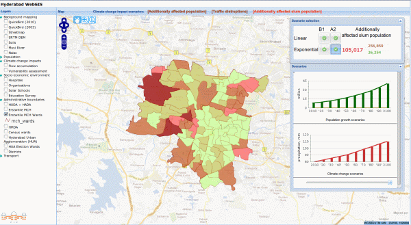
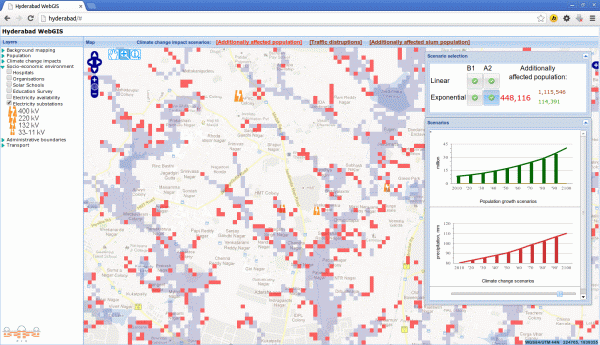
Figure 2. CATHY (Screenshots)
Policy recommendations/ implications
In the next decades urban pluvial flooding in Hyderabad will significantly increase and a new problem - severe heat waves - will arise, both with great certainty. Therefore it should be mandatory that urban planning considers expected climate change impacts as they are projected - in CATHY together with different socio-demographical scenarios - to guarantee climate proof settlement planning.
For example, measures include the avoidance of development in future flood prone areas or the buildup of adequate drainage infrastructure. Furthermore, settlement planning has to take into account the emerging problem of severe heat waves through ventilation corridors and shading. Traffic planning has to consider increasing flood frequencies in presently unproblematic locations and should also refer to the spatially explicit CATHY results. Another important adaptation measure is the planning of secure low cost housing in the neighborhoods of quality housing and production sites. The assumption that Hyderabad's informal settlements will disappear in due time cannot be substantiated with current trend data - so adapting informal settlements to climate change may well be a major task the authorities have to deal with.
Policy Message
Sustainable and efficient urban planning has to assess different scenarios of population and slum development in view of the increase in frequency of rainfall-induced flooding and severe heat waves. Using the Climate Change Assessment Tool for Hyderabad (CATHY) in urban planning will assist in making the following decision processes climate-proof:
Settlement planning (considering future flood prone areas; avoidance of urban heat islands; passive cooling of buildings and streets)
Traffic planning (considering increasing flooding; ascendency of electric public transport)